

MDRRMO La Trinidad
Municipal Disaster Risk Reduction & Management Office
Our Vision: La Trinidad Communities Are Safe, Adaptive to Climate Change, and Disaster Resilient Towards Sustainable Development.
0930-316-1138
0939-350-6636
092-0729-6516
099-9878-6636
(074) 422-4344
0907-117-9901
0927-486-3602
(074) 422-1131
091-0320-7446
0998-555-0093
0998-555-0062
0908-865-7202
0917-592-1698
(074) 422-2796
0910-411-7713
0919-323-1010
(074) 619-4591
(074) 422-4721
0920-924-9083
Preparing For Disasters!
MDRRMO MANDATE:
The La Trinidad MDRRMO is mandated to set the direction, develop, implement and coordinate disaster risk management programs of the La Trinidad Local Government Unit.
Latest News
Latest Tropical Storm #KiyapoPH expected Track.
#LTDRRMO
... See MoreSee Less

0 CommentsComment on Facebook
5:00 AM Update: La Trinidad under TCWS No. 1 due to #KiyapoPH. ... See MoreSee Less

0 CommentsComment on Facebook
Press Briefing: Tropical Depression "Kiyapo" issued at 8:00 PM | July 23, 2026 - Thursday ... See MoreSee Less
0 CommentsComment on Facebook
Northern Part of Benguet is now under TCWS No. 1 (Buguias, Mankayan, Bakun, Kibungan)
As of 5:00PM today.
#LTDRRMO
... See MoreSee Less

1 CommentComment on Facebook
God Bless everyone 💗🙏
Tropical Depression #KiyapoPH TCWS issued 11:00 AM today. ... See MoreSee Less

3 CommentsComment on Facebook
HIGH PRESSURE AREA
.m
.
TROPICAL CYCLONE BULLETIN NR. 2
Tropical Depression #KiyapoPH
Issued at 5:00 AM, 23 July 2026
Valid for broadcast until the next bulletin at 11:00 AM today.
KIYAPO MAINTAINS ITS STRENGTH WHILE MOVING WEST NORTHWESTWARD
OVER THE PHILIPPINE SEA EAST OF CENTRAL LUZON.
• Location of Center (4:00 AM)
The center of Tropical Depression KIYAPO was estimated based on all available data at 950 km East of Central Luzon (15.5°N, 130.5°E).
• Intensity
Maximum sustained winds of 45 km/h near the center, gustiness of up to 55 km/h, and central pressure of 1002 hPa.
• Present Movement
West northwestward at 20 km/h
• Extent of Tropical Cyclone Winds
Strong winds extend outwards up to 400 km from the center
TROPICAL CYCLONE WIND SIGNALS (TCWS) IN EFFECT
• TCWS No.1
Wind threat: Strong winds
Warning lead time: 36 hours
Range of wind speeds: 39 to 61 km/h (Beaufort 6 to 7)
Potential impacts of winds: Minimal to minor threat to life and property
Luzon:
Batanes, Cagayan including Babuyan Islands, Isabela, Apayao, Abra, Kalinga, the eastern and central portions of Mountain Province (Paracelis, Natonin, Barlig, Sadanga, Bontoc, Besao, Sagada), the eastern and central portions of Ifugao (Mayoyao, Aguinaldo, Alfonso Lista, Banaue, Hingyon, Lagawe), Ilocos Norte, the northern portion of Ilocos Sur (Cabugao, Sinait, San Juan, Magsingal, Santo Domingo, Bantay, San Ildefonso, San Vicente), and the northern portion of Aurora (Dilasag, Casiguran)
OTHER HAZARDS AFFECTING LAND AREAS
Heavy Rainfall Outlook
Refer to Weather Advisory No. 8 issued at 5:00 AM today for the heavy rainfall outlook due to TC KIYAPO and the Southwest Monsoon.
Link: tinyurl.com/wxadvisory
Severe Winds
The wind signals warn the public of the general wind threat over an area due to the tropical cyclone. Local winds may be slightly stronger/enhanced in coastal and upland/mountainous areas exposed to winds. Winds are less strong in areas sheltered from the prevailing wind direction.
• Minimal to minor impacts from stro
... See MoreSee Less

0 CommentsComment on Facebook
Public Weather Forecast issued at 5:00 PM | July 22, 2026 - Wednesday ... See MoreSee Less
0 CommentsComment on Facebook
As of 2:00 PM today, 22 July 2026, the Low Pressure Area (LPA 07d) is being monitored inside the Philippine Area of Responsibility (PAR) and has a "HIGH" chance to develop into a Tropical Depression within the next 24 hours. ... See MoreSee Less

0 CommentsComment on Facebook
Today, our office is under the Supervision of PDOFAD (Person With Disability Officer for a Day) MDRRMO Gemma Puyas.
#LTDRRMO
... See MoreSee Less

0 CommentsComment on Facebook
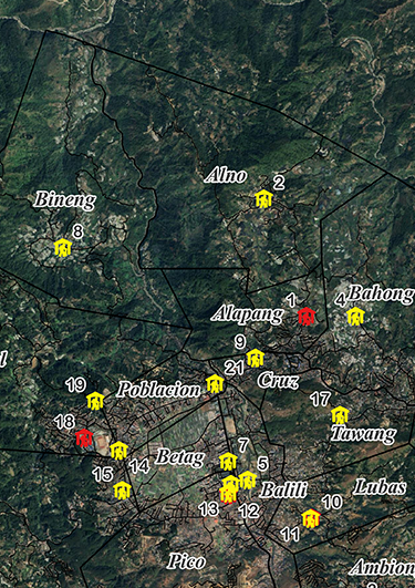
Do you know where to go and how to survive during an emergency?
See our guide on preparing for disasters. Learn how to make a GO bag and see where your nearest evacuation center is. Learn what you can do to be best prepared.
Family Emergency Preparedness Guide
You can create your disaster preparedness plan online


Latest Tropical Storm #KiyapoPH expected Track.
#LTDRRMO ... See MoreSee Less
0 CommentsComment on Facebook
5:00 AM Update: La Trinidad under TCWS No. 1 due to #KiyapoPH. ... See MoreSee Less
0 CommentsComment on Facebook
Press Briefing: Tropical Depression "Kiyapo" issued at 8:00 PM | July 23, 2026 - Thursday ... See MoreSee Less
0 CommentsComment on Facebook